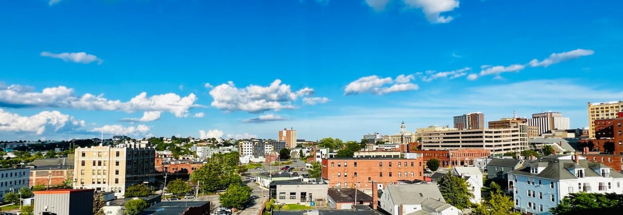
The Bayside Neighborhood, bounded by Forest Avenue on the west, Franklin Street on the east, Congress Street on the south, and I-295 on the north, is experiencing one of the most dynamic transformations in Portland’s history. From its origins beneath Back Cove to its role as an industrial powerhouse and immigrant gateway, Bayside is now emerging as a vibrant mixed-use community that honors its complex past while building an exciting future.

From Back Cove to Solid Ground: The Great Fire and Bayside’s Creation
The story of Bayside begins in an unexpected way: the neighborhood is literally built on Portland’s past. Until the 1850s, much of what is now Bayside lay beneath the waters of Back Cove, which extended much farther into the peninsula, nearly reaching Fox Street and touching Somerset Street.
In 1850, architect and developer Charles Q. Clapp began the first major filling operation, dumping tons of dirt scraped from Munjoy Hill into Back Cove to create a second waterfront for piers and commerce. But it was the catastrophic Great Fire of July 4, 1866 that would truly shape Bayside’s geography.
The Great Fire of 1866
On Independence Day 1866, what began as a firecracker accident near Commercial Street became the largest urban fire in American history at that time. Powered by strong winds and dry conditions, the conflagration swept diagonally across Portland, destroying 1,800 buildings and leaving over 10,000 people homeless—more than a third of Portland’s population.
In the fire’s aftermath, the massive debris from the ruined Old Port—charred wood, brick, and rubble—needed to go somewhere. Much of it was dumped into Back Cove, significantly extending the shoreline and essentially creating East and West Bayside as we know them today. Additional fill was added in the 1960s during the construction of Interstate 295.
While the Great Fire devastated much of Portland, parts of Bayside survived, making it one of the few neighborhoods to retain some of its pre-fire architecture. Today, Greater Portland Landmarks has documented Federal and Greek Revival homes in Bayside that stand as witnesses to this earlier era.
The Railroad Era: Bayside as Industrial Hub
The newly created land became home to Portland’s industrial backbone. A rail yard was built along Somerset Street shortly after the area was filled, and streetcar lines ran along Oxford Street. By the early 20th century, railroads dominated the neighborhood—the Grand Trunk Railway, Maine Central, and Boston & Maine all operated freight yards and switching operations throughout Bayside.
The Portland Terminal Company, formed in 1911 as a joint operation between the Boston & Maine and Maine Central railroads, established numerous freight yards to serve industrial customers. Tracks crisscrossed the neighborhood, extending onto piers along the waterfront and circling the entire peninsula by 1879.
This railroad infrastructure made Bayside the perfect location for industrial operations: foundries, lumber companies, soldering shops, junkyards, the S.D. Warren Paper Mill, and manufacturing facilities. The neighborhood became Portland’s utilitarian center—the industrial zone that powered the city’s economic growth through the mid-20th century.
A Vibrant Immigrant Gateway
As industry grew, so did the immigrant and migrant labor populations who worked these industries. Bayside and East Bayside became a melting pot of new Americans—Italian, Polish, Jewish, Irish, and Armenian communities established vibrant neighborhoods around Franklin Street and throughout Bayside. The “Little Italy” neighborhood south of Franklin was particularly cohesive, despite being home to some of the peninsula’s poorest residents.
This rich diversity and tradition of welcoming newcomers continues today, with more recent African and other immigrant communities contributing to Bayside’s unique cultural fabric.
Urban Renewal and Fragmentation: The 1950s-1970s
The mid-20th century brought devastating changes to Bayside through policies of urban renewal and highway construction. Like many urban neighborhoods across America, Bayside was subjected to redlining, slum clearing, and discriminatory zoning that led to decades of disinvestment.
The Slum Clearance Era
In the 1950s, Portland’s Slum Clearance and Redevelopment Administration began targeting Bayside. In 1958, the Bayside West project eliminated 44 housing units along Franklin Street between Somerset and Congress streets, displacing over 85 residents. The Bayside Park project (now Kennedy Park) razed 54 more units across Franklin Street.
Most devastating was the demolition of the vibrant “Little Italy” neighborhood along Vine, Deer, and Chatham Streets near Franklin Street, which displaced 64 families, 28 individuals, and 27 small businesses in the name of “modernization.”
Franklin Arterial: Severing East from West
In the late 1960s, beginning in 1967, the city undertook its most transformative—and destructive—infrastructure project. Following architect Victor Gruen’s “Patterns for Progress” plan, Franklin Street was completely rebuilt as a four-lane divided highway to funnel traffic from the newly built Interstate 295 to downtown Portland.
At least 130 buildings were demolished along Franklin and its intersecting streets. Entire blocks of row houses overlooking Lincoln Park vanished. The cross streets of Oxford, Lancaster, Federal, and Newbury were severed, their connections between East and West Bayside cut off to promote uninterrupted automobile traffic.
Franklin Street, once a regular two-lane neighborhood street integral to Portland’s diverse East End communities, became Franklin Arterial—a highway-like barrier that separated East Bayside from the rest of the peninsula.
Interstate 295: Cutting Off the Waterfront
Interstate 295’s construction through the 1960s and early 1970s further isolated Bayside. Additional fill was dumped into Back Cove to support the highway, and when I-295 opened through Portland in 1971, it completely severed the neighborhood from Back Cove and the waterfront. The 1984 fire that destroyed the Grand Trunk Railway’s Back Cove Bridge effectively ended railroad access to the waterfront, marking the end of an era.
Railroad Abandonment and Industrial Decline
As industry moved out of Portland in the latter half of the 20th century, the railroad infrastructure that had defined Bayside fell into abandonment. Freight service diminished, rail yards closed, and by the 1990s, most of the track had been removed. The utilitarian buildings and vacant lots that remained became symbols of disinvestment rather than industry.
Addressing Historical Inequities and Building Forward
Today, the Bayside Neighborhood Association, city leaders, developers, and residents are working together to address the historical inequities created by decades of discriminatory policies and disinvestment.
The neighborhood still bears the marks of this difficult history. The east side of Bayside, between Franklin Street and Elm Street, remains one of Portland’s most economically challenged areas. However, the community’s response to these challenges demonstrates remarkable resilience and activism.
Turning Point: Public Works Relocation and Renaissance
The seeds of Bayside’s current transformation were planted in the 2010s when the City of Portland made a crucial decision: to relocate its Department of Public Works operations from their long-time home in Bayside to a new facility on Canco Road.
From City Garage to Community Catalyst
For decades, the city’s Public Works Department had occupied a significant footprint in Bayside—including vehicle maintenance garages, administrative offices, and surface parking lots along Portland Street, Hanover Street, Parris Street, and Kennebec Street. These industrial facilities, totaling 4.1 acres, were functional but represented underutilized land in an increasingly valuable location near downtown.
When Public Works relocated around 2015, the city saw an opportunity. In 2017, Portland issued a Request for Proposals (RFP) for the former Public Works properties, seeking creative, mixed-use development that would transform the neighborhood.The response was overwhelming: eleven developers submitted bids for the six parcels, with proposals ranging from housing and retail to breweries, coffee shops, and maker spaces. The city ultimately selected five local developers, each bringing unique visions for their parcels:
- Tom Watson/Port Property: Acquired multiple parcels, developing 82 Hanover Street with restaurants (Wilson County Barbecue, Banded Brewing, Batson River Brewing & Distilling), fitness studios (CycleBar), and The Armature at 52 Hanover—a 171-unit mixed-use building with workforce housing
- Josh Soley: Developed Parris Terraces at 60 Parris Street with 23 workforce-priced condominiums
- Ross Furman/Szanton Company: Created the Furman Block at 178 Kennebec Street with 51 apartments for residents 55 and older
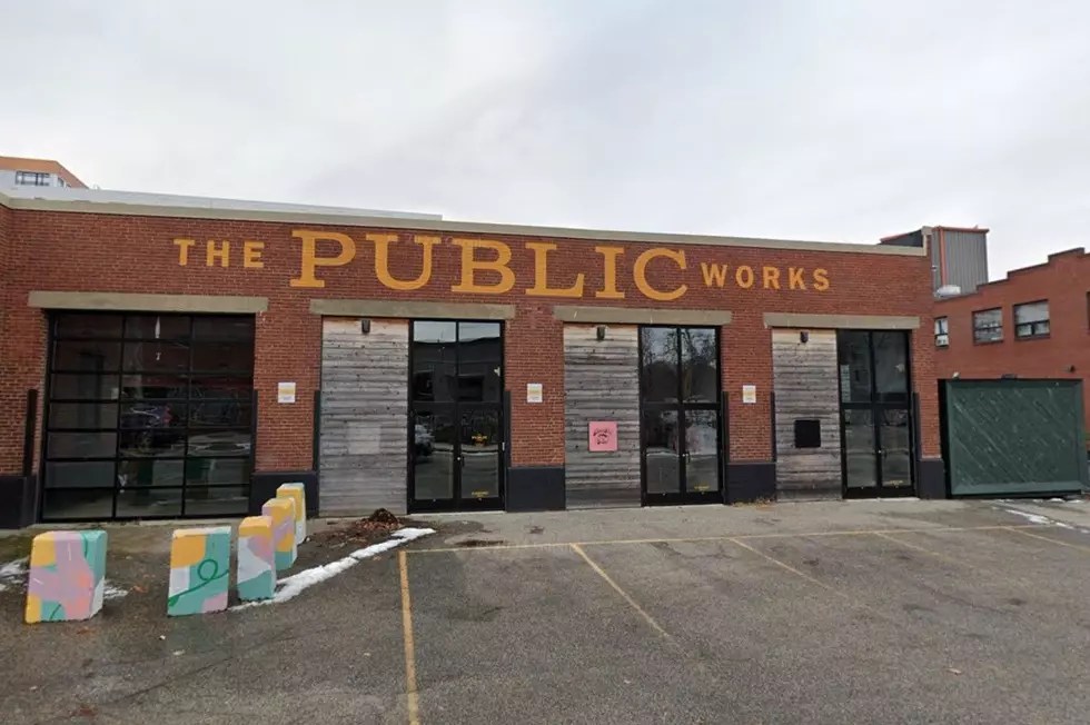
- Rob Barrett: Developed The Public Works maker space at 65 Hanover Street
- Ford Reiche: Renovated office space at 55 Portland Street
This strategic approach—selling to multiple local developers rather than one large entity—created a diverse, community-scaled transformation that built on Bayside’s existing character rather than erasing it.

Growing a Greener Bayside
One of the most visible transformations in Bayside has been the dramatic increase in tree canopy coverage, addressing a long-standing environmental equity issue.
The Bayside Tree Planting Project
Through American Rescue Plan Act and Community Development Block Grant funding, the city has:
- Planted 154+ new trees throughout Bayside (completed 2024)
- Invested $275,000 in tree planting, including specialized tree wells cut into pavement
- Selected native and climate-adapted species including Sassafras, American Yellowwood, Black Gum, Serviceberry, and Redbud
- Committed to planting 100+ large caliper street trees annually for years to come
- Established ongoing care and watering programs to ensure tree survival
The Bayside Neighborhood Association’s Trees & Greens Team continues working with city officials and nonprofits to improve Bayside’s tree equity score and expand green infrastructure throughout the neighborhood.

Community-Driven Vision
Building on “A New Vision for Bayside”
The City of Portland adopted A New Vision for Bayside in 2000 as part of its Comprehensive Plan. While many goals from that visionary document took over two decades to begin materializing, current development efforts are finally bringing those aspirations to life.
View the original vision: Book 1: The Plan and Book 2: Implementation
Active Community Engagement
The Bayside Neighborhood Association (BNA) is one of Portland’s most engaged neighborhood associations, bringing together residents, businesses, and stakeholders to shape the neighborhood’s future. The BNA:
- Operates Portland’s only neighborhood-run community garden at 78 Chestnut Street (established 2001)
- Hosts regular community events and block parties
- Advocates for safe streets, environmental justice, and inclusive development
- Partners with developers and city officials to ensure community priorities are heard
The Bayside Trail
Built in partnership with the City of Portland and Trust for Public Land, the Bayside Trail connects neighborhoods throughout Bayside, offering convenient access to local businesses, scenic areas, and open green space. This essential infrastructure enhances walkability and creates safe, attractive connections throughout the community.
The Bayside Trail is one of the most exciting developments in Bayside in the last few years. This beautiful trail is great for walking or biking and passes through urban and industrial parts of Bayside, while including stretches of grass, trees and meadows. It currently runs from Preble Street up the end of Marginal Way, where it interconnects with the Eastern Prom Trail and the Back Cove Trail. Future plans include extending it to Deering Oaks. The Trust for Public Land and Portland Trails were instrumental in the realization of this vision-come-true:
As a port city, Portland’s waterfront was the town’s identifying feature for its first two and a half centuries, with the “Bayside neighborhood” serving mainly industrial purposes. In 2005, the City of Portland purchased a 13.2-acre former railroad property that runs through the Bayside neighborhood from the Eastern Promenade to Deering Oaks Park. The first step toward fulfilling the vision of a new urban landscape for Portland, TPL stepped in to take the project from concept to reality, spearheading construction and helping to raise the $1.6 million needed to complete the project in 2011.
Today, the Bayside Trail has turned a former industrial area into a livable, walkable, vibrant urban amenity. The trail, together with pocket parks, gardens, and public gathering areas, is a focal point for cultural activities and community programs, contribute to the economic vitality of the city, and improves the quality of life for the tens of thousands of residents, workers, and visitors. In addition to providing a safe, pedestrian friendly pathway through the Bayside neighborhood, this ribbon of green provides a new gateway for Maine’s largest city.
See a map here, at Portland Trails: http://trails.org/our-trails/bayside-trail/
